Sally Outram walk: A wonderful 2.7mile walk around Bawtry and Austerfield


The village of Austerfield sits on the borders of Nottinghamshire and South Yorkshire and is just a stone throw away from the market town of Bawtry, which is just a 20-minute drive from Worksop.
In AD 702, Austerfield was on the border between the two Anglo Saxon Kingdoms of Mercia and Northumbria, its name is Germanic in origin (Ouestraefeld), meaning Eastern field.
Advertisement
Advertisement
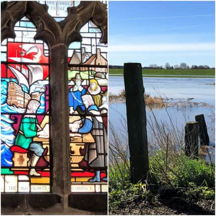
The ancient village has seen many changes through the ages and is possibly best known for its strong links with the Pilgrim Fathers and William Bradford is thought to have lived in Austerfield Manor House with his grandfather and uncles.
William Bradford became a separatist before fleeing to Holland before his epic voyage to America on the Mayflower in 1620, and he became the second elected governor of the Plymouth Colony in Massachusetts in 1621.
By the 1930’s the Manor house was in a poor condition, however, during the second world war, it was frequently visited by American serviceman who came to pay homage to William Bradford’s home.
The beautiful Church of St Helena is definitely worth a visit. The current church was built in the Norman era out of rubble and stone quarried from Roache Abbey.
Advertisement
Advertisement
The south doorway is spectacular, with a splendid example of 12th Century architecture, a beautiful carved Tympanum portraying a carved dragon with an arrow shaped tail.
Inside you can see the magnificent stained-glass windows by Charles Eamer Kempe, and the ones on the north aisle commemorate the 400th anniversary of William Bradford’s baptism at the church, were designed by Septimus Waugh in 1989.
There is also a war memorial which honours the parish men who lost their lives in the great war of 1914 – 1918, this can be found on the south wall of the nave.
As you make your way through the village, you will also notice the old school building. This was built in 1882 and remained a working school until 1972.
Advertisement
Advertisement
In 1973 the Austerfield Study Centre was established, which provides outdoor education for local schools.
Behind the centre is a hundred-acre (Mosaic) Nature Reserve, which is managed by the Mosaic Trust.
The reserve provides a valuable habitat for a variety of wildlife, flora, and fauna, and is a beautiful and peaceful place to connect with nature and to study the environment.
The trust manages and maintains a former sand quarry, which was donated to the local community for leisure purposes and is often used by the study centre as an educational resource.
Advertisement
Advertisement
Just a short distance away from Austerfield is Bawtry and is the perfect place to continue your journey through time.
This eclectic market town is bursting with history and was originally a Roman settlement which was located on Ermine Street, the major Roman road, which ran from London to Lincoln and then on to York, passing through Bawtry.
It is worth taking some extra time to fully explore the quaint streets and alleyways and the beautiful architecture the town has to offer, and there are plenty of places to enjoy a bite to eat after your walk.
Happy Ramblings
Sally
DID YOU KNOW?
Bawtry Hall, once a country house, is more famously known for being the base for RAF No.1 Group Bomber Command during World War Two.
Directions
Advertisement
Advertisement
Begin at the marker post, which is opposite the Recreational Ground on High Street. Continue along the track for a short distance, until you see a gate. Proceed along the footpath which leads to the left and continue along for a short distance until you reach another marker post pointing straight ahead.
Here, turn right and you will see an intersection of paths. Take the left path and proceed along through the pretty woodland area. You can see Bawtry Carbon Factory in the distance. Follow the path for a short distance, continue until you see a path to your left. Follow this path which leads you to the bottom of the quarry area.
Continue along the track towards the wire fence, turn right and proceed along away from the quarry. You will see a wide gravel footpath which goes through a metal structure, proceed along for approximately 0.1 mile until you reach a junction. Take the small track to the left and head towards the woodland area.
Proceed along the path for a short distance and turn right and shortly after turn left along a wider path, continue for a short distance, turn right onto a narrow track which then exits onto High Field Lane, follow to its end and onto Thorne Road.
Advertisement
Advertisement
Turn right onto Thorne Road (A614) proceed along, the road then becomes High Street and head back towards Austerfield. Proceed along until you reach the Austerfield Study Centre, (notice Austerfield Manor to your left) take the footpath which is by the Mosaic Reserve signpost and keep to the left of the wide track.
After a short distance you will come to a path to your left. Proceed along the woodland track until you reach the wide track at the start of the walk. Retrace your steps to the start point.
Basics
Distance: 2.7 miles (4.34 km)
Severity: Easy
Gradient: Mostly flat
Approx. time: 1 ½ to 2 hours at a gentle pace
Stiles: None
Maps: OS Explorer 279 Doncaster, Conisbrough, Maltby & Thorne - OS Landranger 111 Sheffield & Doncaster
Path info: Paths, tracks, woodland tracks
Start point: Recreation Ground, High Street, Austerfield
Parking: Public car park -Thorne Road, charges apply
Dog friendly: Yes, on a lead
Refreshments: There are plenty of places locally to choose from, especially in nearby Bawtry and Blyth