Sally Outram walk: A journey through time around Barlborough


Its history is colourful and rich and was occupied by early settlers who also formed small communities in neighbouring Whitwell, Clowne, and Creswell.
It was documented as Barleburh in 1002, Barleburg in the Domesday book of 1086, and has seen many variations throughout the ages before becoming known as Barlborough.
Advertisement
Hide AdAdvertisement
Hide AdA thriving region, it has evolved throughout the ages, from rural farming to coal mining and has access nationwide via the motorway which is close by.
This lovely little walk takes you on a journey through time, with wonderful views across the countryside.
At the start of the walk you will notice the village school, the original building dates back to 1870 and was commissioned and built by the Rodes family of Barlborough Hall, with the present school building being extended over the years.
Barlborough Hall is a magnificent Tudor mansion which was built by Frances de Rodes in 1583.
Advertisement
Hide AdAdvertisement
Hide AdRodes was a distinguished judge who was famously known for presiding over the trial of Mary Queen of Scots, resulting in her being condemned to her death.
Frances de Rodes never resided in the great hall, in fact he passed away not long after the mansion was completed, leaving his son to assume residency of Barlborough Hall.
The hall has had several owners and uses over the centuries and was also used by the British Army during the World War Two. In 1939 it became an independent Catholic day school in the Jesuit tradition and is now a private preparatory school for nearby Mount St Mary’s College, in Spinkhill.
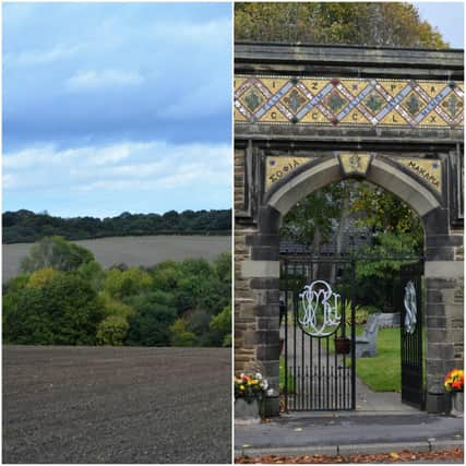
The surrounding countryside is a delight, with superb panoramic views over the Pennines and the Rother Valley. Wildlife is in abundance and there are many photo opportunities to be had along the route.
Advertisement
Hide AdAdvertisement
Hide AdAs you approach the Quarry Dam, you will spot the earth mound, which are the remains of an old mine, which was in use from 1895, until its closure in 1908. The mine provided many jobs for the locals and attracted workers form neighbouring counties to the area, increasing the number of inhabitants in the village.
Quarry Dam is a great spot for bird watching, especially for catching a glimpse of the elusive Kingfisher as it darts across the water.
Walking through the village along the High Street, you will notice a remarkable Victorian archway or gate known as the Golden Gate Memorial Arch, locally referred to as the Mizpah gate.
The elaborately decorated structure was built by William Hatfield de Rodes in memory of his late wife Sophia Felicite Rodes, who died aged 34 of in 1869.
Advertisement
Hide AdAdvertisement
Hide AdThe stonework is beautifully embellished with mosaics and unusual inscriptions which are written in Hebrew, Greek and Latin. The pretty garden beyond the arch was founded in 1951 and symbolises a place for quiet contemplation and haven, it also serves as the war memorial to the brave who lost their life during both world wars.
There is also a memorial to Fred Greaves who was the first recipient of the Victoria Cross in Derbyshire.
Happy rambling!
Sally
DID YOU KNOW?
The distinctive village cross is also situated on the High Street and is a grade 11 listed structure. It is a very unusual and special cross as it is still in its original location. The sandstone base is thought to be the remains of a medieval cross, and the current standing cross dates to around the 18th Century.
Directions
We begin this lovely walk on High Street, by the Primary School. Head towards Ruthyn Avenue and proceed to walk along the footpath until just before California Lane. You will see a path to your right, which takes you through the Laurels.
Advertisement
Hide AdAdvertisement
Hide AdFollow the field edge track bearing right, this follows the line of the motorway. After a short distance turn left and cross the bridge over the motorway following the track to the right, keeping the woodland to your left.
Proceed along the track, you will see a line of hedging/trees to the left, follow this until you reach a stile. Cross over the stile and into a field. You can see the old mine mound to your right.
Follow the track round to the right of the hedge, passing Quarry Dam on your left. (You can view the dam by access over a stile to your left). Continue along to join a farm track, and after a short distance you will see a stile to your left, just before the woods.
Cross over the stile and continue through the woodland path and on until you reach a small stream or ditch. Cross over the ditch and continue along the field edge track until you reach another stile. Cross over the stile and turn right, following the track until you reach the motorway.
Advertisement
Hide AdAdvertisement
Hide AdProceed over the motorway bridge and turn right (waymarked). Walk along, passing a woodland to your right, cross over the cattle grid and continue along passing Barlborough Hall to your left and onto Ward Lane.
Continue along Ward Lane until you reach High Street, Market Cross and the start point.
Basics
Distance: 3.2 miles (4.8km)
Gradient: Mostly flat
Severity: Easy
Approximate time to walk: 2 hours at a leisurely pace
Stiles: 2
Maps: OS 269 Chesterfield & Alfreton
Path description: Woodland, meadows, paths, and tracks
Start point: School
Refreshments: Various pubs in the village to choose from